Collingwood Maps Online
This project has been funded by a Yarra History Grant under the City of Yarra Annual Grants Program. The Plaques Maps and Schools Maps are part of the same project.
Of the many sources of historical information maps can be a particularly rich and fascinating one, showing boundary changes, the pattern of building development, and the more recent changes wrought by overpasses, road widening and freeways. Especially tantalising are those maps which show individual buildings and even gardens and outhouses.
These seven maps were chosen to provide an overview of the City of Collingwood’s development from the 1850s to the 1980s, with the last map showing conditions in existence just prior to the council amalgamations which resulted in the City of Yarra. All maps except the 1980s map are reproduced courtesy of the Map Collection, State Library of Victoria, and may not be reproduced without permission. (For further information about the State Library’s map collection, see http://www.slv.vic.gov.au/search-discover/explore-collections-format/maps). Copies of most of the maps are also available for viewing in the Collingwood History Collection at Collingwood Library by contacting the Information Services Officer. You can see additional maps in the publication Streets and Parks Of Collingwood on our Street Names page.
The maps below are provided in pdf format. You can use the pdf reader to zoom in on the maps. Please note that most of the files are between 4-25mb in size so they will take time to download.
1855?
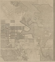 |
Melbourne and its Suburbs, compiled by James Kearney, draughtsman, Andrew Clark, Surveyor General. Download a high quality pdf of this map – File 843 ( |
1858
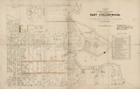 |
Plan shewing the streets and buildings in existence in East Collingwood on January 1st 1858, compiled from surveys executed under the direction of Clement Hodgkinson; photo-lithographed by J. Noone; John Wilkinson surveyor. Download a high quality pdf of this map – File 487( |
1869?
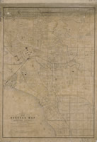 |
H. G. De Gruchy & Co.’s new borough map, Melbourne district; compiled from the most authentic sources, and revised by the official surveys of the various boroughs. Download a high quality pdf of this map – File 874 ( |
1885
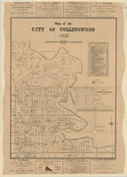 |
City of Collingwood, compiled and lithographed by C. Woodhouse. Download a high quality pdf of this map – File 490( |
1899
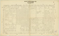 |
Melbourne & Metropolitan Board of Works Detail Download a high quality pdf of this map – Plan No. 1199 & 2000( |
This is just one example of the wonderfully informative plans prepared by the Board of Works in preparation for the introduction of the sewerage system. As well as every house, hotel and shop, surveyors marked any relevant features that might impact on the installation of underground pipes, such as asphalt paths, wash houses, garden beds and downpipes. There are three levels of linked plans:
1. Main grid system (metropolitan Melbourne)
2. Index plans (municipalities)
They are searchable on the State Library’s website at:
1921?
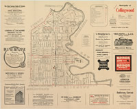 |
Municipality of Collingwood, published by Anderson, Gowan Pty. Ltd. Download a high quality pdf of this map – File 99926 ( |
1980s
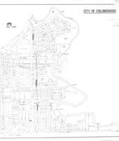 |
City of Collingwood map from the 1980s Download a high quality pdf of this map – File 01-091222 ( |